Posts

Praying for Those in Authority: Yamhill County

Image
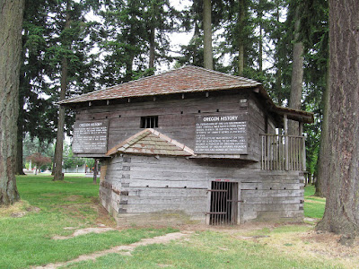
Blockhouse in Dayton, in honor of General Palmer There He makes the hungry dwell, that they may establish a city for a dwelling place, And sow fields and plant vineyards, that they may yield a fruitful harvest. Psalm 107:37-38    Yamhill County, like Clackamas, Champooick, and Twality, was one of the first four districts created by the Oregon Provisional Government in 1843. It was, of course, huge, as the British and Americans has not yet determined who would control the Oregon territory, or where the boundaries should be. Ewing Young, whose untimely and intestate death in 1841 actually precipitated the creation of the Provisional Government (in order to settle his estate), settled in Yamhill County in the 1830’s. As one of the earliest locations in Oregon to be settled, Yamhill County is rich in history. We have written a little about Yamhill and Lafayette here, but there is another small town in Yamhill that has an interesting backstory – Dayton. General Joel Palmer...

Praying for Those in Authority: Lincoln County

Image
  Toledo Church, Lincoln County, OR For evildoers will be cut off; but those wait on the Lord, they shall inherit the land. Psalms 37:9 Lincoln County, named after President Lincoln, is just south of Tillamook County. Its long western edge paralleling the Pacific Ocean, it stretches from Lincoln City in the north to Yachats in the south. Newport, about mid-way, is a popular tourist destination, and is the county seat. Lincoln County is the Central Coast region of Oregon. The economy is supported by tourism, fishing, and timber. A few years ago, I was vacationing in Newport and saw a large multi-storied structure high on a hill. It was in the process of being renovated, but part of it was open as the Pacific Maritime Heritage Center. We were able to tour the open sections. This year, from February 2 to May 7 the Center will present the exhibition of Portraits in Red: Missing and Murdered Indigenous People Portrait Painting Project by indigenous artist Nayana Lafond. So far, she...

Praying for Those in Authority: Tillamook County

Image
Neahkahnie Mountain Those who go down to the sea in ships, who do business on great waters, they see the works of the Lord, And His wonders in the deep. Psalm 107:23-24 Tillamook County was the 12 th to be organized in Oregon’s early days (1853). It has a population of about 27,787 spread over 1,127 square miles. The town of Tillamook is the county seat. This area of the state is full of fascinating and romantic features. The Tillamook State Forest, the reforested site of the catastrophic Tillamook Burn, a series of fires that destroyed 350,000 acres of old growth forest in the coast range during the years 1933 – 1951, is now a beautiful recreation and timber area. Tourism is a big part of the economy with vacationers renting cottages and campsites all along the Pacific Coast. They visit the Tillamook Air Museum at the site of the former Naval Air Station, and the Tillamook Cheese factory as well as the seafood restaurants, saltwater taffy shops, art galleries all up and down Hig...

Praying for Those in Authority: Washington County

Image
  Mt. Hood from Washington County, OR Speak up for those who cannot speak for themselves, for the rights of all who are destitute. Speak up and judge fairly; defend the rights of the poor and needy. Proverbs 31: 8-9 NIV The city of Portland lies within three counties, Multnomah, Clackamas, and Washington. Washington County is mostly made up of the Tualatin Valley which is separated from the northwest edge of Portland by the Tualatin Mountains. One of the smart things Portland did in 1850 was to build a plank road to connect Portland with the Tualatin Valley, ensuring the commerce of Oregon centered on Portland rather than Oregon City. The Tualatin Valley, which contains larger towns such as Beaverton, Forest Grove, and Hillsboro (the county seat), is surrounded by mountains. The Chehalem Mountains separate it from the Willamette Valley itself, and it is bordered on the north and east by the Coast Range. While much of the area is urbanized and Washington County is the second mos...

Praying for Those in Authority: Linn County

Image
  Linn County, OR Father, forgive them, for they do not know what they do.” Matthew 23:34 We are dropping down from the north coast counties for a bit this week and looking at Linn County. This is because the 82 nd Oregon Legislative Assembly began January 17 th   and there  is a great story about "praying for those in authority" I came across, and it has its roots in Linn County. But first…Linn County was established in 1847 by the Provisional Government. At first what is now Brownsville (originally Calapooia) was the county seat, but in 1851 it was moved to Albany.   The county is 2,290 square miles with a population of 128,610. Some of the eastern portion of the county, including the town of Gates, was involved in the 2020 wildfires that came down Santiam Canyon. While much of Linn County is the southern portion of the Willamette Valley and home to larger communities like Albany, the eleventh largest city in the state, the eastern portion of the county leads...

Praying for Those in Authority: Clatsop County

Image
Flavel House, Astoria, OR Let them give glory to the Lord, and declare His praise in the coastlands. Isaiah 42:12 Clatsop County is in the top northwestern corner of the state, bordered by the Columbia River and the Pacific Ocean.  It is home to the oldest American settlement in the Northwest, Astoria, founded by trappers sent out by John Jacob Astor in 1811. Before that, just a bit south, the Lewis can Clark Expedition spent the winter of 1905-6 at Fort Clatsop. You can still visit a replica on the site. Astoria is the county seat, and the county was created in 1844 from a portion of one of the original four districts, Twality. Clatsop County, OR An early settler in Astoria, and one credited with creating modern Astoria, was Captain George Flavel. Born, it is believed, in Ireland, he first caught sight of the little village of Astoria in 1849 when he was shipping supplies during the gold rush. He had sailed around the Horn as a young man from New Jersey to make his fortune in th...

Pray for Those in Authority: Columbia County

Image
Rainier Church, Columbia County, OR When the enemy comes in like a flood, the Spirit of the Lord will lift up a standard against him. Isaiah 59:19 Columbia County was created in 1854. Being in the upper western part of the state, it lies along the Columbia River so saw explorers early in its history, including Captain Grey and his ship in 1792, and Lewis and Clark who camped along the river in Columbia County. The town of St. Helens is the county seat, and the county has a population of around 50,000. At 657 square miles it is the third smallest county in the state. It’s a very rural place, home to farmers and loggers, and with some lovely scenery. The county seat, St. Helens, is on the Columbia River. Roughly thirty miles due west, in the south-west section of the county, is the small town of Vernonia. Before 1924 it was a farming community in the Nehalem River Valley with around 150 people. The Nehalem River bisects the town and Highway 47, known as the Nehalem Highway along th...