Posts

Showing posts from August, 2023

Praying for Those in Authority: Hood River County

Image
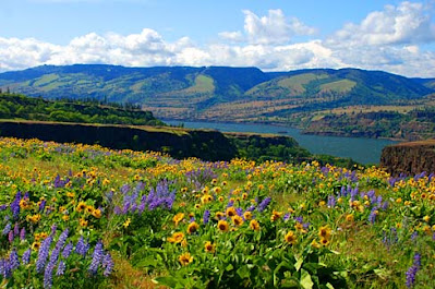
Pine Grove Methodist Church, Oregon Praise the Lord from the earth…Mountains and all hills; fruitful trees and all cedars; Psalm 148: 7, 9 Hood River County is the last of the North Central Region of Oregon that we will cover, a small county in the upper northwest corner of the region right next door to Multnomah County. The county seat is the town of Hood River. It was established in 1908 and is named after the Hood River, a tributary of the Columbia River. It is bordered by the Columbia to the north, Multnomah and Clackamas Counties to the west, and Wasco to the east. By area, at 533 square miles, it is the second smallest county in the state. The population is 23,977. It is a transitional county, lying between the temperate rainforest of the Cascade Mountains, and the dry desert of eastern Oregon. It lies along the Columbia River Gorge, which moderates the rainfall and temperatures with the maritime air that flows up the Columbia to the east. When the wind flows west, out of t

Praying for Those in Authority: Wasco County

Image
Rowena Ridge, Wasco County, OR I will magnify Myself, sanctify Myself, and make Myself known in the sight of many nations; and they will know that I am the Lord.  Ezekial 38:23 Wasco County, created in 1854, was once the largest county in Oregon. It was made up of the parts of Linn, Lane, Marion, and Clackamas Counties that were east of the Cascade Mountains, stretching all the way to the Rocky Mountains, encompassing what became part of Idaho and Montana. The northern border is the Columbia River. Now it has an area of 2,396 square miles and is home to 26,670 people. The county seat is The Dalles. Wasco County, Oregon The Dalles has been occupied for over ten thousand years by Native Americans, and since the 1930s by European settlers and trappers, and is in fact one of the oldest permanently occupied locations in the state. Before pioneers arrived, the tribes gathered here to fish and trade. Several different tribes came from the interior to get in on the Salmon harvest and to trade

Praying for Those in Authority: Jefferson County

Image
Ashwood Road Rock Formations, Jefferson County Open your mouth for the speechless, In the cause of all who are appointed to die. Open your mouth, judge righteously, And plead the cause of the poor and needy. Proverbs 31: 8-9 Jefferson County puts us in the middle of the North Central Region of Oregon. This area is almost all ranching and farming with the town of Madras being the county seat. I had assumed the county was named for Thomas Jefferson, but it is named after Mt. Jefferson, the second-tallest mountain in Oregon – which was named after Thomas Jefferson. The population of Jefferson County is around 25,000. It was created from part of Crook County in 1914. It owes its agricultural and ranching prosperity to the building of the railroad in 1911 that connected Madras to the Columbia River and gave the ranchers and farmers a means of reaching markets. Additionally, the 1930s saw the development of irrigation in the county that expanded farming operations.  Jefferson County, Orego

Praying for Those in Authority: Deschutes County

Image
Deschutes County, Oregon The wilderness and the wasteland shall be glad for them, and the desert shall rejoice and blossom as the rose; Isaiah 35:1 Deschutes County in the southwestern corner of the North Central Region of the state is the newest county in the state, sectioned off from Crook County in 1916. It was named after the river that runs through it, which was named after French-Canadian fur trappers that first explored the region in the early 1800s. The Deschutes River begins in the Cascade Mountains northwest of La Pine, then flows southward into a couple of reservoirs. From the Wickiup Reservoir, the river goes northeast through Sunriver to the city of Bend. From there it goes northward and is joined by the Metolius and Crooked Rivers, forms one of the boundaries of the Warm Springs Indian Reservation, and finally empties into the Columbia River a few miles southwest of Biggs Junction. Deschutes County, Oregon The county seat of Deschutes County is Bend, and while Crook Count

Praying for Those in Authority: Crook County

Image
Crook County, Oregon Blessed are the peacemakers, for they shall be called sons of God. Matthew 5:9 We are moving south from Wheeler into Crook County, which, while still part of the North Central Region of Oregon, is also the state's geographical center. The county was named after General George Crook, a U.S. Army officer, and was formed in 1882. It includes the foothills to the Blue Mountains and was an area hard to reach for settlers until the 1860s when the Santiam Pass was found and developed. Cattle ranchers were the first settlers in the area. Later in the 19 th century, farming was developed, and logging in the Ochoco Mountains. The first mention of a sawmill in county history was of the Swartz mill on Mill Creek around 1867. The current population of the county is 24,738. Prineville is the county seat, and pretty much always has been. The location was settled early in the county’s history, established by Monroe Hodges on his section of land in 1870. He named it after an