Posts

Showing posts from July, 2023

Praying for Those in Authority: Wheeler County

Image
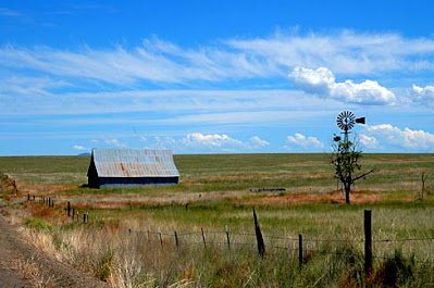
 First Baptist Church of Fossil.  Gary Halvorson, Oregon State Archives O Lord, You are the portion of my inheritance and my cup: You maintain my lot. The lines have fallen to me in pleasant places; Yes, I have a good inheritance. Psalm 16: 5-6 The North Central Region of Oregon contains some of the least populated counties in the state. Wheeler has the distinction of being the county with the lowest population in Oregon at 1,451. Ranchers and farmers originally settled the area, and cattle ranching, agriculture, and timber remain the mainstay of the economy. Fittingly, the county was named for a rancher, Henry H. Wheeler, who owned farmland near the town of Mitchell. Wheeler County lies just to the south of Gilliam County and touches Sherman County on the northwest corner. Wheeler County, Oregon The John Day River is 284 miles long and the original people of the area, the Cayuse, called it the Mah-Hah. It is the fourth-longest free-flowing river in the contiguous United States, unda

Praying for Those in Authority: Sherman County

Image
Sherman County with Mt. Adams For the Lord your God is bringing you into a good land, a land of brooks of water, of fountains and springs, that flow out of valleys and hills; a land of wheat and barley… Deuteronomy 8:7-8 Around 1958 a man named Giles French published the book The Golden Land: A History of Sherman County, Oregon . He wrote: The land that lies between the Deschutes and John Day rivers and north of township five south of the base line in Oregon is Sherman County. It slopes gently north to the Columbia River on what is called by geologists the Shaniko surface…Because of the deep gorges of the Deschutes and John Day rivers running north to the Columbia, Sherman County is a geological and geographical entity. The canyons make it to a marked extent a social and political entity as well. Sherman County, Oregon By the late 1880s the Willamette Valley seemed pretty settled and crowded to those seeking wide open spaces, so restless settlers from the west began moving inland,

Praying for Those in Authority: Gilliam County

Image
  Lonerock Church, Gilliam County, OR He sends out His word and melts them; He causes His wind to blow, and the waters flow. Psalm 147:18 We are moving west from Morrow County and the Northeast Region into the North Central Region beginning with Gilliam County. The county is bordered on the north by the Columbia River and to the east by the John Day River. The North Central Region is still east of the Cascade Mountains for the most part, and much drier than the temperate rainforest to the west of the mountains. The part of Gilliam many of us are most familiar with is the city of Arlington, which lies along I-84 and the Columbia River. It is a convenient stopping place on trips through the Columbia River Gorge. The county is mostly flat but intersected by canyons created by streams out of the Blue Mountains. One mention of Gilliam indicates it is known for “Wheat, Wind, Waves,” a reference to agriculture, the Columbia River, and the windmills that dot the landscape. Shepherds Flat Win

Praying for Those in Authority: Morrow County

Image
Morrow County, Oregon He reveals deep and secret things; He knows what is in the darkness, And light dwells with Him. Daniel 2:22 Described as dry and flat, except for a bit of the Blue Mountains at the southern end, Morrow County is the last county of the Northeast Region of Oregon as we move toward the west. Heppner is the county seat, and Boardman the largest town with a population of 3,828. The entire county has 10,995 people spread over 2, 049 square miles. The Columbia River forms its northern boundary, an important consideration, as it turns out,  in Morrow County’s economic development. In the early days, Morrow was settled by ranchers and farmers, and to a certain extent agriculture and ranching remain the mainstay of the county’s economy, along with food processing, lumber, and recreation. The county was formed in 1885, sectioned off from the western edge of Umatilla County, and named for a state representative, Jackson L. Morrow, who was instrumental in creating the coun