Posts

Showing posts from June, 2022

A Deeper Look: Gilliam County

Image
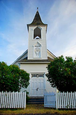
  Lonerock church, Gilliam County [Note: We are recycling an earlier post on Gilliam County, with some minor additions.] The pastures are clothed with flocks; the valleys also are covered with grain; they shout for joy, they also sing . Psalm 65:13 If we are traveling east along I-84 from Sherman County, the next in line, and very similar, is Gilliam County. Like Sherman County, Gilliam was home to the Tenino people who were removed to the Warm Springs Reservation around 1859.   And also like Sherman, it is bordered by rivers: the John Day to the west and the Columbia along the north. It lies at the heart of the Columbia River Plateau wheat-growing area and is known for its production of wheat, barley, and cattle. Gilliam County was created in 1885 and named after Cornelius Gilliam who commander of the military forces in the Cayuse War that took place after the Whitman Massacre. Arlington was originally the county seat but it was later moved 38 miles south to Condon. Arlington

A Deeper Look: Sherman County

Image
John Day Dam, Sherman county. Fishing platform For since the creation of the world God’s invisible qualities—his eternal power and divine  nature—have been clearly seen, being understood from what has been made, so that people are without excuse. Romans 1:20 On our trip to Hermiston last week we drove through Wasco County, then Sherman , which was once part of Wasco. When Wasco was formed in 1854 it was the largest county ever formed in the United States and stretched from the Washington border to the California border, and from the Cascade to the Rocky Mountains. 17 Oregon counties were later created from it, including Sherman in 1889. Moro is the county seat. In the 1880’s there was a “reverse migration” of settlers who arrived in the Willamette Valley only to find the best land already taken. They moved east and began farming and ranching on the dry eastern side of the Cascades. Some immigrants just stopped there and didn’t go on to the western side of the mountains. Enough pop

A Deeper Look: Wasco County

Image
  Wasco County, The Dalles I will magnify Myself, sanctify Myself, and make Myself known in the sight of many nations; and they will know that I am the Lord. Ezekial 38:23 As it happens, I drove through Wasco County this weekend, along I-84. The trip took me to all the counties we have designated the Columbia River Region, the strip along the top of the state bordered by the Columbia River (Hood River, Wasco, Sherman, Gilliam, Morrow). It was wet. Rain is good, and these counties need the rain, but it also can make driving I-84 a challenge. We made it, though – Portland to Hermiston (Umatilla County). As we drive this region, we move through the Cascades and the forests and waterfalls of the Columbia River Gorge to the dry high desert of Eastern Oregon. The landscape changes from lush green mountains to rocky cliffs, to rolling hills dotted with windmills, and flat sagebrush-covered plateaus. The county seat of Wasco County is The Dalles. We wrote about this area earlier here , a

A Deeper Look: Hood River County

Image
Hood River County For as the earth brings forth its bud, as the garden causes the things that are sown in it to spring forth, so the Lord God will cause righteousness and praise to spring forth before all the nations . Isaiah 61:11 Hood River County is the beginning of what I have dubbed the Columbia River Region, comprising Hood River, Wasco, Sherman, Gilliam, and Morrow – all counties with the Columbia River as their northern border. So – Hood River . One of the last counties created in Oregon, it came into being in 1908. Hood River is the County seat. The area has long been known for agriculture, the fertile Hood River Valley famous for fruit orchards and vegetable farms long before the county was formed. A few years ago one of my brothers found a set of Troutdale (Multnomah County) high school yearbooks from the early 1930’s. Our father graduated from that area during that time, so he bought one. He was intrigued by the number of Japanese students listed, children of local fa

A Deeper Look: Lincoln County

Image
Near Yachats, Lincoln County, OR He grants peace to your borders and satisfies you with the finest of wheat . Psalms 147:14NIV At one time Lincoln County was mostly the Siletz Indian Reservation. The area also was difficult to access for many years until roads were built in the twentieth century, as a result there is a bit less pioneer history than in some counties.  Lincoln County was created out the western portions of Benton and Polk Counties in 1893 and lies just south of Tillamook County. The county seat is Newport. Lincoln County The treatment of the Native tribes in this area, and the history of the Coast Indian Reservation makes for sad reading. You can learn more here . While numerous tribes were removed to the Coast Indian Reservation during the 1850’s, the original tribes in southern Lincoln County were the Alsea and Yaquina coastal Indians. They all but disappeared during the chaotic years of European settlement and relocation of the tribes, but the town of Yachats, in