Posts

Showing posts from July, 2020

Praying for Oregon Counties: Lane

Image
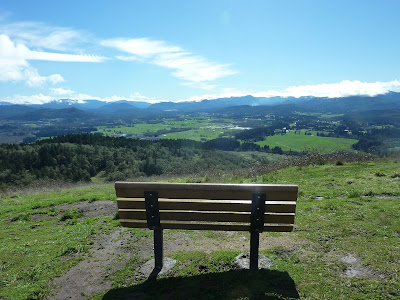
View from Mt. Pisgah in Lane County Violence shall no longer be heard in your land, neither wasting nor destruction within your borders; But you shall call your walls Salvation, and your gates Praise.  Isaiah 60:18 The thought of Lane County automatically leads to thoughts of Eugene, one of the population centers of Oregon. It rivals Salem in population, so is either the second or third largest city in the state, depending on your source of information. The county itself has about 77 people per square mile, and is the fourth most populated county in Oregon. It was established in 1851 and carved, like many of Oregon counties, out of parts of others - in this case Benton and Umpqua. It was named after Oregon Territory’s first governor, Joseph Lane. Over the years there have a been a dizzying number of changes to the county’s borders. Basically, the changes made it much smaller – it once went all the way to the California border – but also extended it to the Pacific Ocean. Theref

Praying for Oregon Counties: Multnomah

Image
Mount Hood, Oregon Your mercy, O Lord, is in the heavens; Your faithfulness reaches to the clouds. Your righteousness is like the great mountains; Your judgments are a great deep;  Psalm 36: 5-6   We turn our attention to Multnomah County, but most eyes, and news cameras, are fixed there already. Multnomah County is the smallest in land - 466 square miles - and the largest in population…and influence. Compare Multnomah with 1705 people per square mile, to Malheur County with three. This is, of course, due to Portland, the largest city in the state, which is also the county seat. In fact, since 1968 the county government has had a consolidated city-county government and there have been some attempts to merge the city-county government into one unit.  Multnomah was created in 1854 out of the eastern edge of Washington County and a northern strip of Clackamas County. Its northern border is the Columbia River. The county isn’t all Portland, however. The eastern por

Oregon Prayer Spotlight: Garibaldi

Image
Garibaldi, Oregon   O Lord, how manifold are Your works! In wisdom You have made them all. The earth is full of Your possessions— This great and wide sea, In which are innumerable teeming things, Living things both small and great.  Psalm 104: 24-25   We’ve been going through Oregon county by county, but would like to take a moment to spotlight individual communities as we go through the state. For this post we are focusing on the coastal community of Garibaldi, known as "Oregon's Authentic Fishing Village." Garibaldi is in Tillamook County, one of the counties where I do have roots. I have family about half an hour to the south, near Pacific City. More on Tillamook County in a later post. My last trip through Garibaldi was just last fall when some friends and I stayed in Rockaway Beach, a few miles north. As the guide for my out-of-state friends, my plan was to ride the Oregon Coast Scenic Railroad train from Rockaway to Garibaldi, but we were distrac

Praying for Oregon Counties: Crook

Image
Image by  jimo663  from  Pixabay Then it shall be to Me a name of joy, a praise, and an honor before all nations of the earth, who shall hear all the good that I do to them; they shall fear and tremble for all the goodness and all the prosperity that I provide for it.  Jeremiah 33:9     Crook County, Oregon is in the geographical center of Oregon. The county seat, and only incorporated town, is Prineville. When I think of Crook County and Prineville I think of the “lonesome high dessert,” sagebrush, pine, juniper...and agates and thundereggs. But, to be perfectly accurate, the true Oregon High Dessert is to the south and east, more in Lake, Harney and Malheur Counties, but Crook is traditionally cattle ranches and agriculture, pine trees and coyotes. There have been some changes of late, however. In 1882 the Oregon Legislature formed Crook County out of part of Wasco County, naming it after General George Crook, a veteran of the Civil War.  Image by  Tom Burgess  from

Praying for Oregon Counties: Curry

Image
Image by  tdfugere  from  Pixabay For they shall partake of the abundance of the seas And of treasures hidden in the sand.  Deuteronomy 33:19 Some of my family members have driven down Highway 101, the Oregon coast highway, to Curry County in the extreme southwest corner of Oregon and then on to California just across the county line. Usually those trips are to visit the redwoods in Northern California. I am more familiar with I-5, which passes to the east of Curry County, so haven’t seen much of this gem of the Oregon coast. Established in 1855, it was split off from Coos County to the north. Curry County is bordered by the Pacific Ocean to the west, California to the south, Josephine County to the east and just a touch of Douglas County on the northeastern corner. It is one of Oregon’s smaller counties in size, but there are about 13 people per square mile, so a bit more populated than the counties east of the mountains. For many years travel along the southern Ore